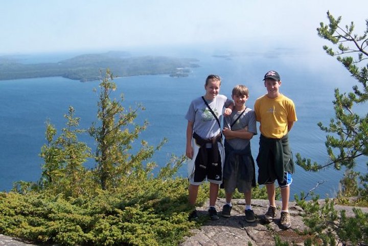
Minnesota’s North Shore of Lake Superior is one of the best hiking destinations in the Midwest.
During your stay at Okontoe (or on your way up or back), be sure to take some time to explore at least a couple of these.
Hiking is so good along the North Shore that an entire trail system has been developed there from Duluth to Canada—the Superior Hiking Trail (SHT).
It has the perfect combination of the biggest freshwater lake in the world—Lake Superior—high bluffs and (Midwest-style) mountains and forests. Dozens of rivers flow from higher inland to the lake, many with impressive waterfalls as they make their way down towards the Big Lake.
Much of this area has remained protected by state forest, state parks and national forest, so there’s a lot of public land available for hiking.
Many private landowners have also graciously allowed trails to wind through their property, making the entire system interconnected.
Our Pick: The Best Hiking Trails on the North Shore
We chose these 13 as the best hiking spots on Minnesota’s North Shore because:
- The trailhead is either right on or just a few minutes off of Highway 61.
- They’re achievable for most people, including children and the “olders.” Some are quite strenuous, and being fit will help. None are over 5 miles, and most are 3 miles or less.
- They’re gorgeous. If we’re going to make the effort and take the time to hike, we want out-of-the-ordinary beauty. You’ll notice something about this list: they either have rivers and waterfalls or big overlooks.
Busy Season: Summer, hands-down. Some of these will be crowded any day of the week in June, July and August. Weekends through September and October can also be very busy. Keep in mind that most of these can be hiked via snowshoe in the winter! A totally difference experience.
This tour starts just 10 minutes past Two Harbors and continues northeast to the Canadian border. Several of these make a super day trip from Okontoe, if you can enjoy a lengthy stay with us (a week is perfect!):
Gooseberry Falls • Gooseberry Falls State Park
There are a total of five waterfalls in this last section of the Gooseberry River before it spills into Lake Superior.

There are 18 miles of trails here in the state park. But the most beautiful are those that lead to the several waterfalls, especially the Lower Falls. They’re also the easiest to get to…and the busiest!
From the main falls area, keep following the Lower Rim Trail .75 miles east to Lake Superior. Hang out at the pebble beach for awhile, swim on a hot day (in very cold water!) and bring a picnic.
If you head upriver from Lower Falls, you’ll reach Upper Falls just past the highway. Want to add 2.4 miles to your hike? Keep going on the Fifth Falls Loop. The trail will bring you back to connect with the Visitor Center again.
Summer is SO busy here—Gooseberry is Minnesota’s 2nd most popular state park. But 80% of the people stick near the Upper and Lower Falls. Start hitting the trails further out and you’ll feel much less crowded. Even cross the river on the footbridge below Lower Falls and you’ll be among far fewer people.
Here’s a map of the trail system at Gooseberry. This is available at the Visitor Center, too. (State Park Permit not needed if you park by the Visitor Center—although that lot is often full during the summer, especially mid-day.)
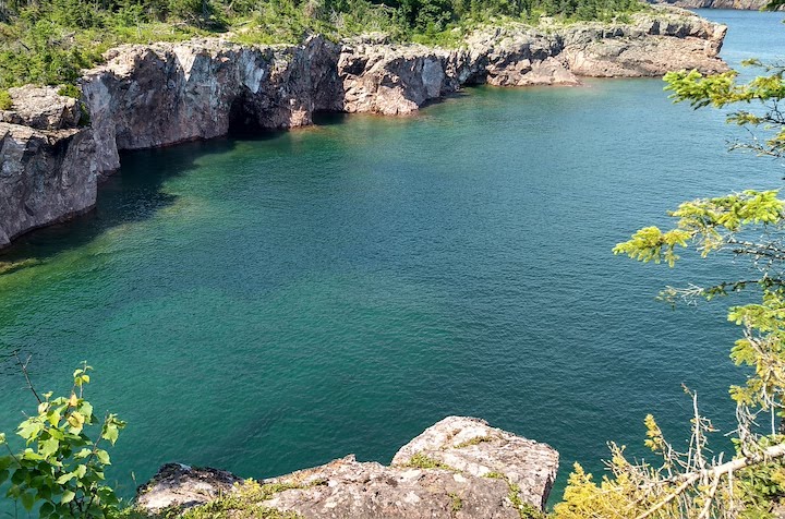
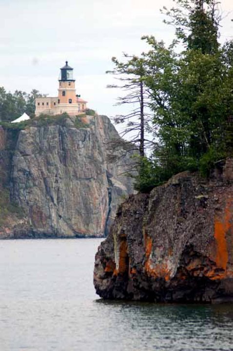
Split Rock River Loop • Split Rock Lighthouse State Park
There’s great hiking both on the Split Rock River Loop Trail and on the trails on the lake side of Highway 61 that bring you eye-to-eye with the famous lighthouse.
The trail begins at the large parking area on the north/west side of Highway 61. It follows the river upstream for a couple miles before connecting with the SHT.
To hike along the lakeshore you’ll need to drive into the state park (vehicle permit required and well worth the cost). There are a couple parking areas with trail access. While not lengthy, these trails are fun to explore with direct cobblestone beach access and wonderful views of the lighthouse from below.
The park is also extremely busy in the summer, with parking challenges on weekends and mid-day.
Here’s a map of the trail system in Split Rock, including the river loop.
High Falls of the Baptism River • Tettegouche State Park
The 3-mile out-and-back hike to High Falls begins at the Tettegouche Visitor Center parking lot. You’ll walk down the park road towards the Baptism River, and take the trail under the highway bridge, heading inland.
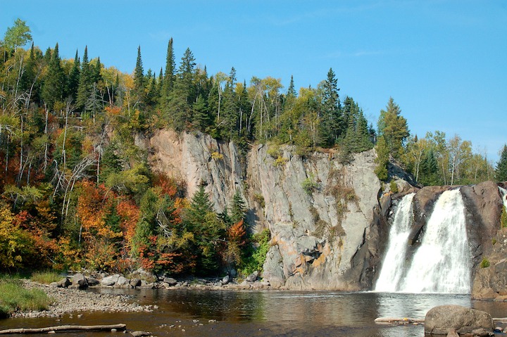
The trail keeps far up above the river most of the way, among a mixed hardwood and boreal forest. About a mile in, take the spur trail that leads down to Two Step Falls. The river widens into a large pool here before continuing down towards Superior.
Then head back up to the main trail to High Falls. There’s a footbridge across the river just above the falls that gives you a gorgeous view of the river valley, 60 feet down. Take the steps up to the bridge, and also the trail down to the river to view the falls and surrounding cliffs from river-level.
This is the highest waterfall that’s completely within Minnesota’s borders. (High Falls in Grand Portage State Park is twice the size, but we share it with Canada!)
Here’s a map of the trail system at Tettegouche. There are 23 total miles of trails here. The Superior Hiking Trail traverses the park, crossing the Baptism River at High Falls.
Shovel Point • Tettegouche State Park
This is one of the shortest hikes on the list, but absolutely one of the most dramatic! The 1.4-mile loop out to the end of Shovel Point starts just behind the Tettegouche Visitor Center.

Before too long there’s a spur trail heading off to the right down to Lake Superior’s shore. Take that for great views from lake level both towards the south and towards the north and Shovel Point itself.
Back up on the main trail there are a few overlooks as it climbs higher and higher. Eventually you’ll reach the top, where you’ll be a couple hundred feet above Lake Superior looking southwest to the mouth of the Baptism River and Palisade Head.
This spot is hugely popular with rock climbers, so it’s not uncommon to see a few there.
If you continue on you’ll leave most of the other travelers behind, while enjoying several more overlooks. You’ll eventually reach the end of Shovel Point with Lake Superior’s beautiful blue-green water on three sides. Follow the trail to the north side of the point for views far up the northeast shore, then loop back.
(The map above for the Baptism River includes the Shovel Point hike)
The rest on this list are very possible to do as a day trip from Okontoe. All (except the last two Grand Portage hikes) are 45-60 minutes from camp:
Temperance River • Temperance State Park
Pull off into one of the parking areas on either side of Highway 61. The trail up the river gorge begins here and heads away from the lake. The hike itself is short, but it’s so beautiful you won’t want to rush it!
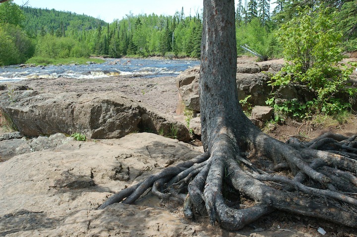
There’s some fun rock scrambling to be had, as well as a well-traveled trail.
This lower section of the Temperance River thunders through the gorge, dropping several times in dramatic waterfalls. There are a handful of overlooks along the river before it climbs up a bit to the top where the river flattens and widens with a beautiful view of the river valley and inland hills.
Hang out at the top of the falls, and you can also keep hiking for awhile along the river if you choose. You can even follow the trail all the way to our next, destination, Carlton Peak.
Here’s the map for the Temperance trail system.
Carlton Peak
Carlton Peak is Minnesota’s 2nd highest point at 1,526 feet. The 3-mile out-and-back trail gets quite steep and vigorous as you approach the summit, so good knees are a definite plus!
Part of this trail winds its way through a birch and aspen forest, part along moss-covered rocks with peeks through the trees to the Sawtooth Mountains around you. It’s really beautiful!
As you near the summit, you’ll need to take a switchback spur trail. If you start heading downhill again, you’ve missed it! (if you keep going you’ll end up at the Temperance River in a mile or two…which is a great hike if you have a car you can leave there, too!)
The summit gives spectacular, open views of Lake Superior and the inland Sawtooth Mountains.
There’s another short spur trail to Tofte Peak, which is worth the 5 minutes it’ll take you to get there. Not quite as dramatic, but it has better views of Lake Superior.
To get to the trailhead, take Highway 2 off 61 in Tofte and drive up a couple miles. The trailhead parking lot is for both Carlton Peak and Britton Peak.
(Britton Peak, incidentally, isn’t one of the most spectacular hikes, but it’s short and very steep, and looks over to Lake Superior and Carlton Peak. If you’re looking for a great workout, this is it! Your heart rate will definitely go up and your quads will burn!)
Here’s a map for Carlton Peak.
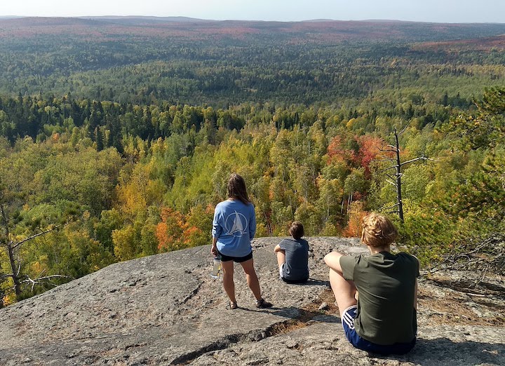
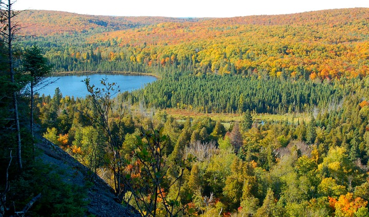
Oberg Mountain
The Oberg Mountain Loop hike is considered by many to be Minnesota’s best fall color hike. It’s loaded with maple trees, and overlooks the surrounding Sawtooth Mountains, which are also loaded with both yellow and orange maples. It is, indeed, gorgeous in the fall!
But it’s gorgeous the rest of the year, too, so don’t skip it if you can’t be there the end of September or early October.
What makes this trail so spectacular are the several overlooks, all with amazing views of Lake Superior the Sawtooth Mountains and/or Oberg Lake. It’s easy, too, just 1.5 miles altogether with a short stretch of a not-too-difficult switchback.
Take Onion River Road off Highway 61 between Tofte and Lutsen, and drive up a couple miles to the parking area on the left. Then walk back across the road to the trailhead.
Here’s a map for the Oberg trail.
Cascade River • Cascade State Park
The trailhead along the Cascade River begins right off Highway 61, and you can choose either side of the river. You can walk up as far as you choose, as it keeps going upriver along the Superior Hiking Trail all the way to Canada!

This hike is known for its series of cascading waterfalls in the final section of the river before it feeds into Lake Superior. Truly gorgeous! Foot bridges and boulders give you many options for great views, and large cedar trees give it a lush feel that’s quite unique here.
Here’s a map for Cascade.
Pincushion Mountain
Of this list, the hike to Pincushion may have the least dramatic journey along the trail, but one of the most dramatic overlooks once you reach the summit of Pincushion Mountain!
Aside from a steep 25-foot boulder scramble near the summit, it’s an easy trail. It’s 5 miles around the whole loop, or you can save a mile and hike out to the summit and back.
This trail is well-known in the area for its great cross-country skiing. You’ll find the trailhead a couple miles up the Gunflint Trail outside of Grand Marais. Look for the trailhead sign on the right.
Here’s the map for Pincushion (take the lower green trail).
Kadunce River
There’s a nice 2-mile out-and-back segment along the bank of the Kadunce River. Hike up to where it joins the Superior Hiking Trail at the footbridge.
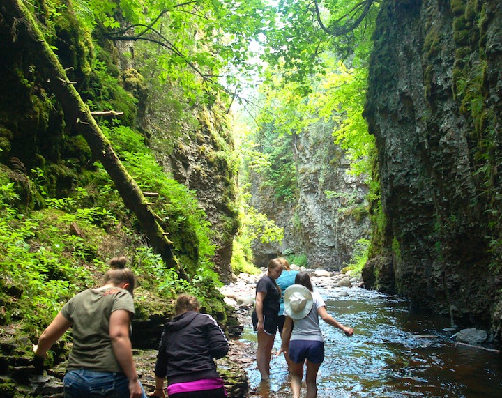
For a really cool experience, though, hike IN the river! Don’t do this in the spring or after heavy rains when the water’s high. But this river is shallow enough that, with sturdy water shoes, you can make your way up the river to the first waterfall. Trekking poles are great here, too.
If you’re with at least one other able-bodied, fit hiker, consider continuing upriver, scrambling up the several waterfalls you’ll meet on your way to the footbridge.
One thing you can’t see from the trail above that’s absolutely awesome is the 100-foot high canyon walls the river winds through in some areas. You feel like you’re in the jungles of somewhere that’s not Minnesota!
Look for the trailhead sign and parking area along Highway 61 between Covill and Hovland.
Here’s a map for Kadunce (scroll down the list and click).
Devil’s Kettle Falls • Judge CR Magney State Park
You’ll need a state park permit to get to the trailhead for Devil’s Kettle. But don’t let that stop you—it’s well worth it! (Besides, we want to support the parks that maintain these wonderful hiking trails!)

This trail follows the Brule River and includes at least one beautiful vista high above the river, and several alongside its banks.
While short (2 miles out-and-back), this is a vigorous hike on account of the couple hundred steps built into the trail. You’re rewarded with gorgeous waterfalls, including the mysterious Devil’s Kettle Falls. Half the river flows into a cauldron, the other half continues over the falls and downriver.
It wasn’t until 2017 that the DNR decided it knows where the water from the cauldron comes back out into daylight.
Drive into Magney State Park off Highway 61 between Covill and Hovland (past Kadunce).
Here’s a map for Devil’s Kettle.
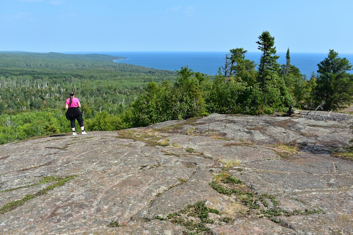
Mt. Josephine
Mount Josephine is way up by Grand Portage, 45 miles past Grand Marais. This 1,342-foot peak isn’t as high as Carlton Peak, but it seems so because it juts directly out of Lake Superior. The views here are some of the most spectacular anywhere in the state!
This hike is short, but steep and vigorous—another one that demands good knees! It’s 2-3 miles up-and-back, depending where you begin (more on that below).
The trail winds through forest up and up, with occasional views of the lake and the Susie Islands to give you an idea of your progress. Just before the summit there are wonderful overlooks with vistas of the Lake Superior, the Susie Islands, the Canadian shoreline and, on a clear day, Isle Royale in the distance.
On the summit itself are the remains of an old fire tower, with glorious views of the inland terrain—and loads of blueberry bushes if you happen to be here in July or August!
The trailhead is a bit of a trick to find. See our post where we give a detailed explanation!
The best map we could find was this Google map. The trail itself isn’t on the map, but the trailhead is.
High Falls of the Pigeon River • Grand Portage State Park
Finally, right at the Canadian border, is this easy, paved hike along the Pigeon River to Minnesota’s highest waterfall. 130-foot High Falls thunders down among the trees and dramatic rock cliffs.
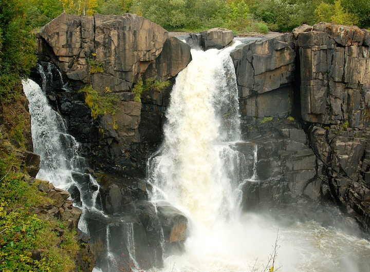
There are many spur trails down to the river where you can explore the banks. You’ll have to make your way back to the main trail in order to see the falls, though.
There are a couple different wooden platforms the DNR has build, and you’ll want to get to both of them for every view. If you have your passport, consider going across the border to the Canadian side and seeing it from that vantage point, too.
The hike to High Falls is just a mile round-trip, although another three miles or so upriver is Middle Falls. It’s a more demanding hike if that’s what you’re looking for.
The trailhead is just shy of the border patrol building, on the left into the State Park parking area.
A day trip to Grand Portage from Okontoe is very doable and well worth the time and effort. You can take in both these last two hikes, plus a visit to the Fur Trading Post there. It’s about 1.5 hours from camp.
Here’s a map for High Falls.
There are so many great trails along the North Shore, it’s hard to pick just one or two.
The best strategy is to check out one or two new ones on every Okontoe trip 🙂
Book Your Stay at Okontoe Today
(Article and photos by Sharon Brodin, except where noted)
1 thought on “The Best Hiking Trails on the North Shore”
Comments are closed.